Hampshire 5km square maps
Compiled by John Norton. Last updated 8 May 2025.
Introduction
These maps show the distribution of bryophyte taxa recorded in Hampshire (VC11 & 12) plotted at 5km square (quadrant) resolution. The maps are derived from records in the BBS/BRC database together with those submitted but not yet incorporated and those not yet submitted up to December 2024 for VC12 and April 2025 for VC11. See the Hampshire hectad maps introduction for further information and acknowledgements. The taxonomic arrangement and mapping symbology is the same as used for the hectad maps.
The maps were generated from records in the British Bryological Society (BBS) database (administered by the Biological Records Centre, BRC), together with those submitted but not yet incorporated into the the database and those compiled but not yet submitted by the Hampshire recorders (up to December 2024 for VC12 and April 2025 for VC11). The maps were produced using the Tom.bio plugin for QGIS, developed for the Field Studies Council. Note that the captions on the maps are automatically generated from the taxon list used, and the plugin removes hyphens and punctuation.
As at May 2025 a total of 498 maps have been produced. The following 15 taxa are not included as the records were entered at hectad precision only: Ephemerum crassinervium subsp. sessile, Entosthodon mouretii, Leptodontium gemmascens, Dicranum flagellare, Scapania curta, Schistochilopsis incisa, Solenostoma paroicum, Cephaloziella turneri, Pohlia elongata, Haplomitrium hookeri, Plagiochila spinulosa s.l., Polytrichum perigoniale, Racomitrium heterostichum, Didymodon ferrugineus, Plagiochila bifaria. However, several of these were single county records and the collection locality is likely to be known.
Analysis
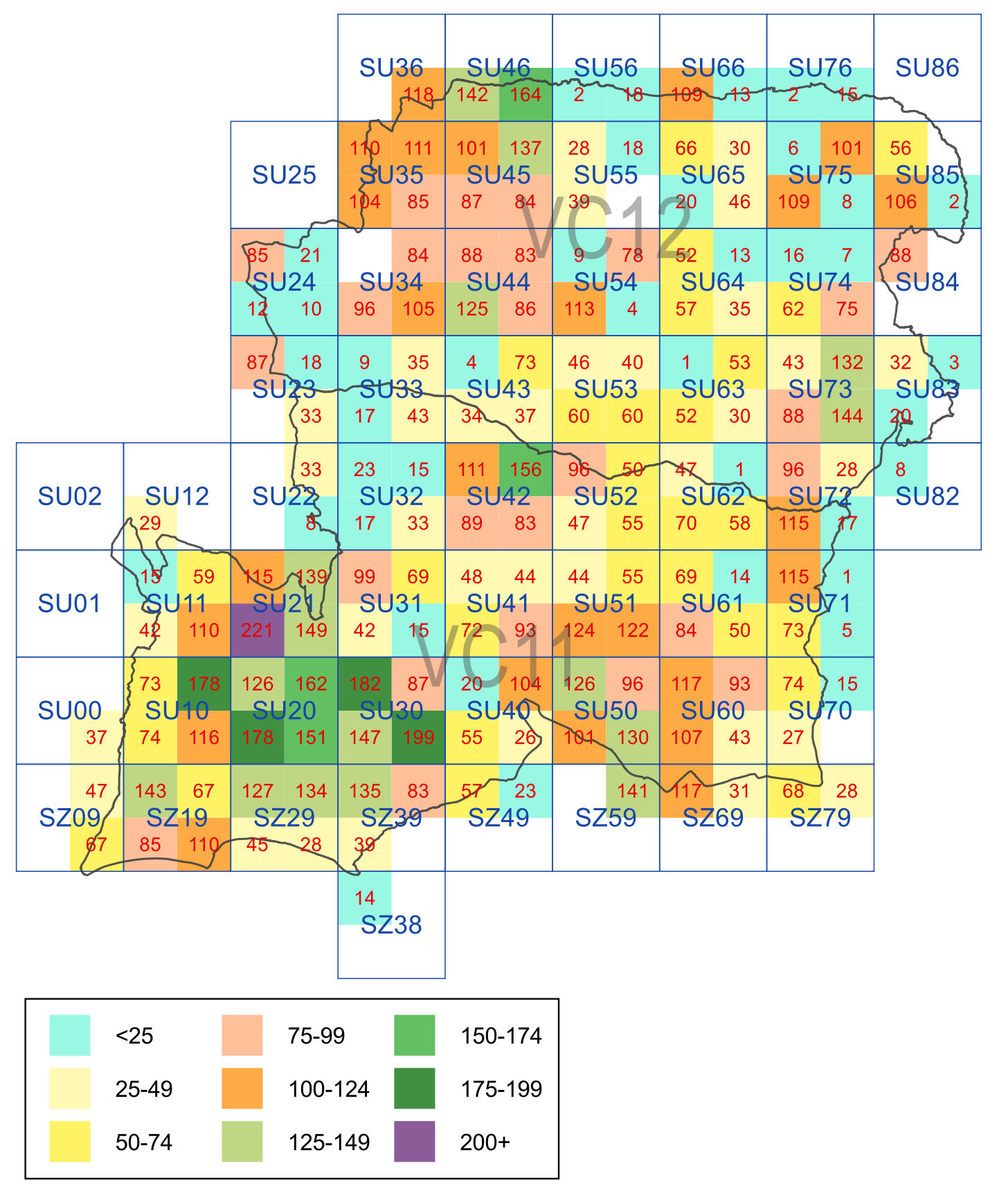
Species richness for quadrants
The map below shows the species richness in terms of number of taxa recorded in each 5 x 5km square. As with the hectad map this clearly indicates that the richest bryophyte areas are in the New Forest and in the east of the county, particularly the eastern half of SU73 where there is a mixture of chalk downland, calcareous woodland and heathland. It is interesting that the best recorded square is in the north-west of the New Forest (SU21SE, 321 taxa), which lies outside the core area of ancient wood pasture but has a good mixture of typical New Forest habitats; the next highest square is in the south-east of the New Forest (SU30SE) with 22 fewer taxa.
The map also reflects better recording (as well as better quality habitats) in the home localities of the two vice-county recorders (Winchester, SU42NE and Gosport, which includes SU50SE and SZ59NE). However, because most of the older records in the BBS database were only given to hectad precision (so not shown here), this map to some extent reflects the level of more recent recording effort in the county (i.e. especially across rural areas where richness will be expected not to vary greatly). The pale blue squares with fewer than 25 taxa recorded should be prioritised for future recording visits. It can also be seen that the western half of VC12 appears to be much better recorded than the eastern half – this is at least partly down to incomplete data entry of 5km square record cards held by a previous recorder. Note that white squares lying on or within the county boundary mean that there are no records at all or that records were only input as hectad grid references. Contains OS data © Crown Copyright and database right 2025.